
Parcel 34-2N-23-0000-0001-0040
Owners
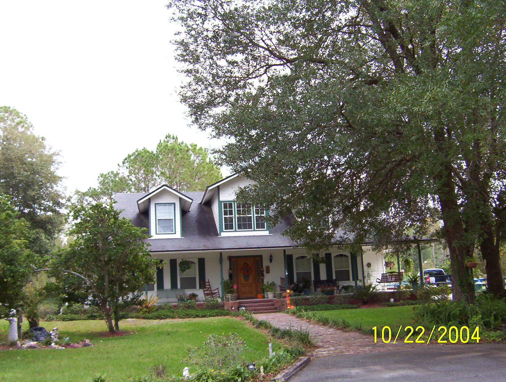
20319 COUNTY ROAD 121
HILLIARD, FL 32046
Parcel Summary
| Situs Address | 20319 CR 121 |
|---|---|
| Use Code | 5000: IMPROVED AG |
| Tax District | 6: Drainage Dist |
| Acreage | 12.4900 |
| Section | 34 |
| Township | 2N |
| Range | 23 |
| Subdivision | |
| Exemptions | HX: Homestead (196.031(1)(a)) (100%) HB: Homestead Banded (196.031(1)(ab) (100%) |
Short Legal
PT OF NE1/4 OF NE1/4 OFSEC 34-2N-23E & PT OF SE1/4 OF
SE1/4 OF SEC 27-2N-23E...
Values
| 2025 Preliminary Values | 2024 Certified Values | |
|---|---|---|
| Land Value * | $87,030 | $62,640 |
| (+) Improved Value | $388,483 | $374,505 |
| (=) Market Value | $608,408 | $566,330 |
| (-) Agricultural Classification | $3,605 | $3,815 |
| County Assessed Value | $243,307 | $236,762 |
| (=) School Taxable Value *** | $218,307 | $211,762 |
| (=) County Taxable Value | $192,585 | $186,762 |
Document/Transfer/Sales History
| Instrument / Official Record | Date | Q/U | V/I | Sale Price | Ownership |
|---|---|---|---|---|---|
| QC 2609/1326 | 2022-12-20 | U | Improved | $100 | Grantor: TAYLOR DANESE E Grantee: TAYLOR DANESE E & CINDY L |
| WD 0595/0516 | 1990-04-19 | U | Vacant | $55,000 | Grantor: THOMAS FOREST & DONN Grantee: TAYLOR DANESE E |
| MS 0513/1064 | 1987-03-27 | U | Vacant | $36,000 | Grantor: TANNER KENNETH E SR Grantee: THOMAS FOREST & D L |
Buildings
Building # 1, Section # 1, 326188, RESIDENTIAL
| Heated Sq Ft | Year Built | Value |
|---|---|---|
| 2763 | 1998 | $340,434 |
Structural Elements
Extra Features
| Code | Description | Length | Width | Units | Unit Price | AYB | % Good Condition | Final Value |
|---|---|---|---|---|---|---|---|---|
| 0940 | SHEDS/PORT | 8 | 12 | 96.00 | $20.10 | 1980 | 20% | $386 |
| 0525 | GAZEBO | 1.00 | $2,500.00 | 1998 | 25% | $625 | ||
| 0500 | FP-PRE FAB | 1.00 | $3,500.00 | 1998 | 80% | $2,800 | ||
| 0100 | BAR-B-Q | 1.00 | $200.00 | 1999 | 20% | $40 | ||
| 0680 | POLE SHED WD | 12 | 10 | 120.00 | $10.00 | 1999 | 26% | $312 |
| 0811 | CONCRETE B | 1062.00 | $5.20 | 1998 | 73% | $4,031 | ||
| 0680 | POLE SHED WD | 42 | 24 | 1008.00 | $7.50 | 1990 | 20% | $1,512 |
| 0803 | ASPHALT C | 11488.00 | $2.00 | 1999 | 50% | $11,488 | ||
| 0855 | CONC PAVER | 138.00 | $7.00 | 2006 | 86% | $831 | ||
| 0825 | BRICK | 50 | 6 | 300.00 | $8.75 | 1999 | 93% | $2,441 |
| 0861 | POOL GUNITE | 25 | 16 | 400.00 | $85.00 | 2005 | 36% | $12,240 |
| 0871 | POOL HTR R | 1.00 | $2,000.00 | 2005 | 22% | $440 | ||
| 0845 | KOOL DECK | 923.00 | $7.25 | 2005 | 84% | $5,621 | ||
| 0911 | SCRN RM A | 49 | 28 | 1372.00 | $17.50 | 2005 | 22% | $5,282 |
Land Lines
| Code | Description | Zone | Front | Depth | Units | Rate/Unit | Acreage | Total Adj | Value |
|---|---|---|---|---|---|---|---|---|---|
| 005000 | AGRICULTURAL HOMESITE | OR | .00 | .00 | 1.64 | $45,000.00/AC | 1.64 | 1.00 | $73,800 |
| 005501 | TIMBER 2 P SI 80-89 | OR | .00 | .00 | 7.00 | $515.00/AC | 7.00 | 1.00 | $3,605 |
| 009530 | POND | OR | .00 | .00 | 3.85 | $2,500.00/AC | 3.85 | 1.00 | $9,625 |
| 009910 | MARKET VALUE AGRICULTURAL | OR | .00 | .00 | 7.00 | $19,500.00/AC | 7.00 | 1.00 | $136,500 |
Personal Property
None
TRIM Notices
Property Record Cards
Disclaimer
The Nassau County Property Appraiser's Office makes every effort to produce the most accurate information possible. No warranties, expressed or implied, are provided for the data herein, its use or interpretation. The information contained herein is for ad valorem tax assessment purposes only. The Property Appraiser exercises strict auditing procedures to ensure validity of any transaction received and posted by this office but cannot be responsible for errors or omissions in the information received from external sources. Due to the elapsed time between transactions in the marketplace, and the time that those transactions are received from the public and/or other jurisdictions, some transactions will not be reflected.